
Ogilby's Road Maps - 1675
Cat No.: GB1044:
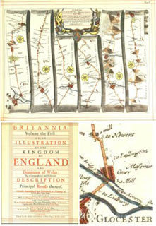
The full title of this wonderful set of maps is:
An Illustration of the Kingdom of England and Dominion of Wales: by a Geographical and Historical Description of the Principal Roads thereof.
By John Ogilby 1675
Basically, what we have here are over 100 route maps (some of them spanning several pages) between principal places in England and Wales, showing all cross roads and road intersections, mileposts, villages and towns though which the roads pass, hills, mountains and forests, rivers, streams, and fords, bridges, etc. Even the type of bridge is noted, for example, stone arches, wooden with rails, etc.
When our ancestors travelled, these were the routes that they used.
Wonderful maps that are a delight to examine, and of course, for you to extract to include in your own family history files. A superb reference for your collection. Zoom in and in on screen to view the finest detail.
FULL COLOUR (Scanned using the very latest generation Bookeye A2 colour scanner).
Reproduced in PDF format for viewing using Adobe Acrobat Reader.
No. of CDs is: 1 ; Format is: PDF ; Searchable?: ;
FastFind: No; ISBN No.: unavailable;